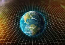
In this case we are not talking about a tuber, but about the three-dimensional reconstruction of the Earth by means of a new model that represents the variations of gravity. The virtual image, called in English as Potsdam Gravity Potato – Potsdam’s gravitational potato -, has been developed by scientists at the German Center for Geophysical Research in Helmholtz. Due to its great precision – no more than a few centimeters of error – it can serve as a universal reference to study sea level , its evolution and variations in the Earth’s gravitational field.
The difference with the geoid, the theoretical representation that joins the points of equal gravity, is that these experts have not obtained a solid and static figure, but its surface varies with time. This occurs because, although we tend to think that the force of attraction is a uniform constant, the gravitational field of the planet changes to a great extent due to factors such as the uneven distribution of mass between the oceans, the continents and the inner layers of the planet. Cortex.
Parameters related to the climate and the hydrological cycle also influence, such as the melting of glaciers and the water balance in reservoirs and surface currents. To develop their model, the German scientists used 800 million data, from both land-based measurements and the European Space Agency (ESA) LAGEOS, GRACE and GOCE satellites. The sensors of the latter, dedicated to studying the Earth’s gravitational field and its anomalies, are capable of collecting parameters of the deep seabed and recording changes in sea level, which is known as dynamic ocean topography.